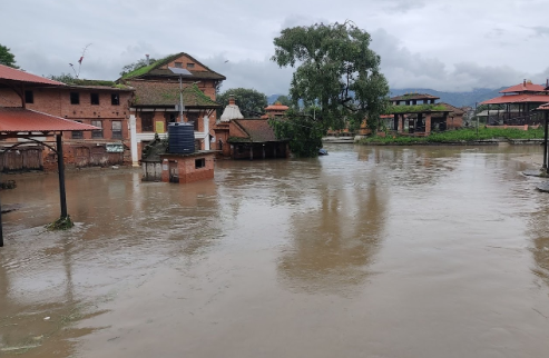
Flooding in Kathmandu Valley
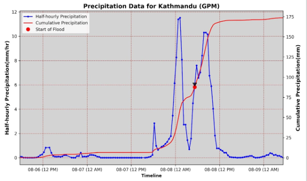
It is a general phenomenon that flood occurs with heavy rainfall. The flood becomes a problem when they affect people and property. The heavy rainfall on August 8th caused flooding in almost all the major settlements around the rivers of Kathmandu Valley. According to reports from the Weather Forecasting Division, persistent downpours began on the night of August 7th which continued till the morning resulting in rainfall exceeding 80mm in various parts of the valley. This continuous rain generated excess runoff, leading to widespread floods in the rivers and streams. The impact was particularly felt on Monday night when river settlements were inundated. Areas nearby rivers like Kalimati, Mulpani, UN Park, Chyasal, and Radheradhe were heavily affected. Unfortunately, this flooding scenario along the banks of rivers like Bagmati, Bishnumati, Dhobikhola, Hanumante, Nakkhu, Balkhu, and Manohara is an annual recurrence.
As highlighted in the Nepal Disaster Report 2019, Bhaktapur and Kathmandu are the most affected districts by flood events. Due to its urban expansion, the densely populated Kathmandu Valley faces a unique challenge. With the city's rapid growth, there has been an increase in impervious surfaces, which decreases the travel time for the water to rivers causing a quick response to the rainfall that triggers peak runoff within a short period. Encroachment of the river corridors is a major factor contributing to flood vulnerability. As the population expands and available land remains limited, the construction of buildings encroaches upon these natural pathways. This constriction of the river channels significantly elevates the risk of flash floods occurring. The majority of the vulnerable areas in the valley are once upon a time the river banks and in some cases they were the flow path of the rivers. The constricted river pathway and obstructed flow are the major causes of the flood impacts in the areas nearby the rivers. Likewise, considering the rapid urbanization of Kathmandu, it's evident that the existing drainage system, established years ago, needs upgrading and revisions to handle the intensity of monsoon rains. Consequently, areas like Putalisadak, Teku, and Bhaktapur experience flooding due to inadequate drainage capacity, preventing excess rainwater from efficiently reaching the nearby rivers. This caused urban flooding in the areas that are far from the rivers.
As the country's capital city, Kathmandu Valley urgently requires a planned way of management of the urban sprawls. Development of essential physical infrastructure such as embankments, dams, and bridges along its riverine paths might be a solution to some extent, however, it's critical to approach this infrastructure development cautiously, as constructing structures like dams, embankments, and bridges within river pathways can disrupt their natural flow and increase sedimentation elevating the riverbeds and potentially lead to the more flooding extents. The raised banks with narrowed flow paths increase the water velocity. This concern is particularly evident in the Kathmandu valley, where existing embankments along rivers like Dhobikhola, Bishnumati, Bagmati, Hanumante, and Nakhu have narrowed the waterways raising the risk of downstream flooding.
The constricted river pathway and obstructed flow are the major causes of the flood impacts in the areas nearby the rivers.
Balancing urban growth, flood prevention, and mitigation are crucial for the sustained development of Kathmandu Valley. Validated research outcomes should be integrated into planning, policy-making, and development strategies to minimize flood risk in Kathmandu. Key measures include integrated, interdisciplinary, coordinated disaster preparedness strategies. Since flood is not bounded by political boundaries, a catchment scale must plan to be formed. Upstream and downstream coordination only provide the implacable solution. Preparation of flood hazard maps, updating the codes and bye-laws such as proper flood plain demarcation and restriction of any kind of construction in the areas, raising house plinth levels in possible flooding areas, improving drainage systems, establishing multi-hazard risk profiles, and implementing reliable flood forecasting and Early Warning Systems. Evacuation plans, optimal disaster fund allocation, and mainstreaming risk reduction in development are also vital for enhancing flood resilience. The mainstream idea of flood prevention and mitigation measures needs an amalgamation of scientific studies along with proper policy formation and planning. For this proper scientific communication among the policymakers is essential.